
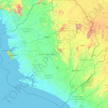
Sierra Leone topographic map
Interactive map
Click on the map to display elevation.
About this map
Name: Sierra Leone topographic map, elevation, terrain.
Location: Sierra Leone (6.75500 -13.50034 9.99997 -10.27168)
Average elevation: 187 m
Minimum elevation: -2 m
Maximum elevation: 1,628 m
Other topographic maps
Click on a map to view its topography, its elevation and its terrain.
Europe
In general, Europe is not just colder towards the north compared to the south, but it also gets colder from the west towards the east. The climate is more oceanic in the west and less so in the east. This can be illustrated by the following table of average temperatures at locations roughly following the 64th,…
Average elevation: 223 m
United States
The Rocky Mountains, west of the Great Plains, extend north to south across the country, peaking at over 14,000 feet (4,300 m) in Colorado. Farther west are the rocky Great Basin and deserts such as the Chihuahua, Sonoran, and Mojave. The Sierra Nevada and Cascade mountain ranges run close to the Pacific…
Average elevation: 309 m
United Kingdom
Scotland accounts for just under one-third (32 per cent) of the total area of the UK, covering 78,772 square kilometres (30,410 sq mi). This includes nearly 800 islands, predominantly west and north of the mainland; notably the Hebrides, Orkney Islands and Shetland Islands. Scotland is the most mountainous…
Average elevation: 42 m
Ukraine
Average elevation: 183 m
Chennai
India > Tamil Nadu > Chennai
Chennai is located on the south–eastern coast of India in the north–eastern part of Tamil Nadu on a flat coastal plain known as the Eastern Coastal Plains. Its average elevation is around 6.7 metres (22 ft), and its highest point is 60 m (200 ft). Chennai is 2,184 kilometres (1,357 mi) south of Delhi,…
Average elevation: 8 m
India
Average elevation: 1,017 m
Florida
Economic prosperity in the 1920s stimulated tourism to Florida and related development of hotels and resort communities. Combined with its sudden elevation in profile was the Florida land boom of the 1920s, which brought a brief period of intense land development. In 1925, the Seaboard Air Line broke the FEC's…
Average elevation: 6 m
Pennsylvania
Pennsylvania's diverse topography also produces a variety of climates, though the entire state experiences cold winters and humid summers. Straddling two major zones, the majority of the state, except for the southeastern corner, has a humid continental climate (Köppen climate classification Dfb). The…
Average elevation: 340 m
Israel
At the other extreme, mountainous regions can be windy and cold, and areas at elevation of 750 metres (2,460 ft) or more (same elevation as Jerusalem) will usually receive at least one snowfall each year. From May to September, rain in Israel is rare. With scarce water resources, Israel has developed various…
Average elevation: 410 m
California
California's mountains produce rain shadows on the eastern side, creating extensive deserts. The higher elevation deserts of eastern California have hot summers and cold winters, while the low deserts east of the Southern California mountains have hot summers and nearly frostless mild winters. Death Valley, a…
Average elevation: 929 m
Germany
Elevation ranges from the mountains of the Alps (highest point: the Zugspitze at 2,963 metres or 9,721 feet) in the south to the shores of the North Sea (Nordsee) in the northwest and the Baltic Sea (Ostsee) in the northeast. The forested uplands of central Germany and the lowlands of northern Germany (lowest…
Average elevation: 237 m
Turkey
Average elevation: 487 m
North Carolina
North Carolina is defined by a wide range of elevations and landscapes. From west to east, North Carolina's elevation descends from the Appalachian Mountains to the Piedmont and Atlantic coastal plain. North Carolina's Mount Mitchell at 6,684 feet (2,037 m) is the highest point in North America east of the…
Average elevation: 163 m
Michigan
The heavily forested Upper Peninsula is relatively mountainous in the west. The Porcupine Mountains, which are part of one of the oldest mountain chains in the world, rise to an altitude of almost 2,000 feet (610 m) above sea level and form the watershed between the streams flowing into Lake Superior and Lake…
Average elevation: 259 m
Sweden
At 449,964 km2 (173,732 sq mi), Sweden is the 55th-largest country in the world, the fifth-largest country in Europe, and the largest country in Northern Europe. The lowest elevation in Sweden is in the bay of Lake Hammarsjön, near Kristianstad, at −2.41 m (−7.91 ft) below sea level. The highest point is…
Average elevation: 163 m
New Jersey
High Point in Montague Township, Sussex County is the state's highest elevation at 1,803 feet (550 m) above sea level. The state's highest prominence is Kitty Ann Mountain in Morris County, rising 892 feet (272 m). The Palisades are a line of steep cliffs on the west side of the Hudson River in Bergen and…
Average elevation: 72 m
Texas
With 10 climatic regions, 14 soil regions and 11 distinct ecological regions, regional classification becomes problematic with differences in soils, topography, geology, rainfall, and plant and animal communities. One classification system divides Texas, in order from southeast to west, into the following:…
Average elevation: 518 m
Indonesia
Average elevation: 81 m
Japan
Average elevation: 58 m
Africa
Average elevation: 462 m
Syria
Average elevation: 537 m
Vietnam
Due to differences in latitude and the marked variety in topographical relief, Vietnam's climate tends to vary considerably for each region. Vietnam is a country located in the tropics, however Northern Vietnam, including Hanoi, is considered a subtropical region by Köppen climate classification. During the…
Average elevation: 173 m
Colorado
Thirty days later on February 28, 1861, outgoing U.S. President James Buchanan signed an Act of Congress organizing the free Territory of Colorado. The original boundaries of Colorado remain unchanged except for government survey amendments. The name Colorado was chosen because it was commonly believed that…
Average elevation: 2,060 m
Tennessee
Tennessee has diverse terrain and landforms, and from east to west, contains a mix of cultural features characteristic of Appalachia, the Upland South, and the Deep South. The Blue Ridge Mountains along the eastern border reach some of the highest elevations in eastern North America, and the Cumberland Plateau…
Average elevation: 233 m
Thailand
Thailand comprises several distinct geographic regions, partly corresponding to the provincial groups. The north of the country is the mountainous area of the Thai highlands, with the highest point being Doi Inthanon in the Thanon Thong Chai Range at 2,565 metres (8,415 ft) elevation. The northeast, Isan,…
Average elevation: 156 m
Poland
The native Polish name for Poland is Polska. The name is derived from the Polans, a West Slavic tribe who inhabited the Warta River basin of present-day Greater Poland region (6th–8th century CE). The tribe's name stems from the Proto-Slavic noun pole meaning field, which in-itself originates from the…
Average elevation: 194 m
Netherlands
Netherlands literally means "lower countries" in reference to its low elevation and flat topography, with only about 50% of its land exceeding 1 m (3.3 ft) above sea level, and nearly 26% falling below sea level. Most of the areas below sea level, known as polders, are the result of land reclamation that began…
Average elevation: 251 m
Australia
Average elevation: 35 m
Ireland
Average elevation: 44 m
Scotland
A significant exception to the above are the fossil-bearing beds of Old Red Sandstones found principally along the Moray Firth coast. The Highlands are generally mountainous and the highest elevations in the British Isles are found here. Scotland has over 790 islands divided into four main groups: Shetland,…
Average elevation: 36 m
Dubai
Dubai lies directly within the Arabian Desert. However, the topography of Dubai is significantly different from that of the southern portion of the UAE in that much of Dubai's landscape is highlighted by sandy desert patterns, while gravel deserts dominate much of the southern region of the country. The sand…
Average elevation: 64 m
Egypt
Average elevation: 272 m
Romania
The Danube, Europe's second-longest river, rises in Germany's Black Forest and flows in a southeasterly direction for 2,857 km (1,775 mi), before emptying into Romania's Danube Delta. The Carpathian Mountains, which cross Romania from the north to the southwest, include Moldoveanu Peak, at an altitude of 2,544…
Average elevation: 355 m
Washington
Washington is the 18th-largest state, with an area of 71,362 square miles (184,830 km2), and the 13th-most populous state, with more than 7.7 million people. The majority of Washington's residents live in the Seattle metropolitan area, the center of transportation, business, and industry on Puget Sound, an…
Average elevation: 796 m
Massachusetts
Despite its small size, Massachusetts features numerous topographically distinctive regions. The large coastal plain of the Atlantic Ocean in the eastern section of the state contains Greater Boston, along with most of the state's population, as well as the distinctive Cape Cod peninsula. To the west lies the…
Average elevation: 128 m
Monmouth County
In 1910, the Wright Brothers hosted an aviation show in Interlaken, where numerous records were broken, such as high altitudes, longest time airborne, the first night flight, and the first air mail delivery.
Average elevation: 19 m
Greece
Eighty percent of Greece consists of mountains or hills, making the country one of the most mountainous in Europe. Mount Olympus, the mythical abode of the Greek Gods, culminates at Mytikas peak 2,918 metres (9,573 ft), the highest in the country. Western Greece contains a number of lakes and wetlands and is…
Average elevation: 170 m
Spain
Mainland Spain is a rather mountainous landmass, dominated by high plateaus and mountain chains. After the Pyrenees, the main mountain ranges are the Cordillera Cantábrica (Cantabrian Range), Sistema Ibérico (Iberian System), Sistema Central (Central System), Montes de Toledo, Sierra Morena and the Sistema…
Average elevation: 331 m
Golan Heights
Israel > North District > Golan Regional Council
The plateau that Israel controls is part of a larger area of volcanic basalt fields stretching north and east that were created in the series of volcanic eruptions that began recently in geological terms, almost 4 million years ago. The rock forming the mountainous area in the northern Golan Heights,…
Average elevation: 533 m
Georgia
Georgia is defined by a diversity of landscapes, flora, and fauna. The state's northernmost regions include the Blue Ridge Mountains, part of the larger Appalachian Mountain system. The Piedmont plateau extends from the foothills of the Blue Ridge south to the Fall Line, an escarpment to the Coastal Plain…
Average elevation: 136 m
Mexico
Mexico is crossed from north to south by two mountain ranges known as Sierra Madre Oriental and Sierra Madre Occidental, which are the extension of the Rocky Mountains from northern North America. From east to west at the center, the country is crossed by the Trans-Mexican Volcanic Belt also known as the…
Average elevation: 412 m
Istanbul
Because of its hilly topography and maritime influences, Istanbul exhibits a multitude of distinct microclimates. Within the city, rainfall varies widely owing to the rain shadow of the hills in Istanbul, from around 600 millimeters (24 in) on the southern fringe at Florya to 1,200 millimeters (47 in) on the…
Average elevation: 57 m
Italy
Conditions on the coast are different from those in the interior, particularly during winter months when the higher altitudes tend to be cold, wet, and often snowy. The coastal regions have mild winters and hot and generally dry summers; lowland valleys are hot in summer. Average winter temperatures vary from…
Average elevation: 293 m
Belgium
Average elevation: 138 m
Denmark
Spanning a total area of 42,943 km2 (16,580 sq mi), it consists of the peninsula of Jutland and an archipelago of 443 named islands, of which the largest are Zealand, Funen and the North Jutlandic Island. Denmark's geography is characterised by flat, arable land, sandy coasts, low elevation, and a temperate…
Average elevation: 30 m
Jordan
The climate in Jordan varies greatly. Generally, the further inland from the Mediterranean, there are greater contrasts in temperature and less rainfall. The country's average elevation is 812 m (2,664 ft) (SL). The highlands above the Jordan Valley, mountains of the Dead Sea and Wadi Araba and as far south as…
Average elevation: 674 m
Maine
Geologists describe this type of landscape as a "drowned coast", where a rising sea level has invaded former land features, creating bays out of valleys and islands out of mountain tops. A rise in land elevation due to the melting of heavy glacier ice caused a slight rebounding effect of underlying rock; this…
Average elevation: 198 m
Houston
United States > Texas > Harris County
Much of the city was built on forested land, marshes, or swamps, and all are still visible in surrounding areas. Flat terrain and extensive greenfield development have combined to worsen flooding. Downtown stands about 50 feet (15 m) above sea level, and the highest point in far northwest Houston is about 150…
Average elevation: 25 m
Finland
Much of the geography of Finland is a result of the Ice Age. The glaciers were thicker and lasted longer in Fennoscandia compared with the rest of Europe. The eroding effects have contributed to a mostly flat landscape in Finland, characterized by hills. However, in the northern regions, including areas…
Average elevation: 201 m
Switzerland
Switzerland lies between latitudes 45° and 48° N, and longitudes 5° and 11° E. It contains three basic topographical areas: the Swiss Alps to the south, the Swiss Plateau or Central Plateau, and the Jura mountains on the west. The Alps are a mountain range running across the central and south of the…
Average elevation: 1,016 m
France
Metropolitan France has a wide variety of topographical sets and natural landscapes. Large parts of the current territory of France were raised during several tectonic episodes like the Hercynian uplift in the Paleozoic Era, during which the Armorican Massif, the Massif Central, the Morvan, the Vosges and…
Average elevation: 430 m
Lebanon
Average elevation: 638 m
North America
Average elevation: 294 m
Mississippi
Mississippi is entirely composed of lowlands, the highest point being Woodall Mountain, at 807 ft (246 m) above sea level, in the northeastern part of the state. The lowest point is sea level at the Gulf Coast. The state's mean elevation is 300 ft (91 m) above sea level.
Average elevation: 74 m
Arkansas
Arkansas's plant life varies with its climate and elevation. The pine belt stretching from the Arkansas delta to Texas consists of dense oak-hickory-pine growth. Lumbering and paper milling activity is active throughout the region. In eastern Arkansas, one can find Taxodium (cypress), Quercus nigra (water…
Average elevation: 156 m
Kenya
Kenya's climate varies from tropical along the coast to temperate inland to arid in the north and northeast parts of the country. The area receives a great deal of sunshine every month. It is usually cool at night and early in the morning inland at higher elevations.
Average elevation: 717 m
Tamil Nadu
The annual rainfall of the state is about 945 mm (37.2 in) of which 48 per cent is through the northeast monsoon, and 32 per cent through the southwest monsoon. Since the state is entirely dependent on rains for recharging its water resources, monsoon failures lead to acute water scarcity and severe drought.…
Average elevation: 253 m
Brazil
Brazilian topography is also diverse and includes hills, mountains, plains, highlands, and scrublands. Much of the terrain lies between 200 meters (660 ft) and 800 meters (2,600 ft) in elevation. The main upland area occupies most of the southern half of the country. The northwestern parts of the plateau…
Average elevation: 368 m
New Hampshire
Average daytime highs are in the mid 70s°F to low 80s°F (24–28 °C) throughout the state in July, with overnight lows in the mid 50s°F to low 60s°F (13–15 °C). January temperatures range from an average high of 34 °F (1 °C) on the coast to overnight lows below 0 °F (−18 °C) in the far north and…
Average elevation: 293 m
Austria
According to the Köppen Climate Classification Austria has the following climate types: Oceanic (Cfb), Cool/Warm-summer humid continental (Dfb), Subarctic/Subalpine (Dfc), Tundra/Alpine (ET) and Ice-Cap (EF). It is important to note though that Austria may experience very cold, severe winters, but most of the…
Average elevation: 595 m
Birmingham
Birmingham is a snowy city relative to other large UK conurbations, due to its inland location and comparatively high elevation. Between 1961 and 1990 Birmingham Airport averaged 13.0 days of snow lying annually, compared to 5.33 at London Heathrow. Snow showers often pass through the city via the Cheshire gap…
Average elevation: 138 m
Asia
Average elevation: 563 m
Saudi Arabia
Saudi Arabia's diverse geography is dominated by the Arabian Desert, associated semi-desert, shrubland, steppes, several mountain ranges, volcanic lava fields and highlands. The 647,500 km2 (250,001 sq mi) Rub' al Khali ("Empty Quarter") in the southeastern part of the country is the world's largest contiguous…
Average elevation: 551 m
China
Average elevation: 901 m
Norway
Little has been found dating from the early Iron Age (the last 500 years BC). The dead were cremated, and their graves contain few burial goods. During the first four centuries AD, the people of Norway were in contact with Roman-occupied Gaul. About 70 Roman bronze cauldrons, often used as burial urns, have…
Average elevation: 143 m
Indiana
The average altitude of Indiana is about 760 feet (230 m) above sea level. The highest point in the state is Hoosier Hill in Wayne County at 1,257 feet (383 m) above sea level. The lowest point at 320 feet (98 m) above sea level is in Posey County, where the Wabash River meets the Ohio River. The resulting…
Average elevation: 226 m
Russia
Average elevation: 150 m
Portugal
Despite the calamity and huge death toll, Lisbon suffered no epidemics and within less than one year was already being rebuilt. The new city centre of Lisbon was designed to resist subsequent earthquakes. Architectural models were built for tests, and the effects of an earthquake were simulated by having…
Average elevation: 268 m
Mauritius
Average elevation: 0 m
Glasgow
United Kingdom > Scotland > Glasgow City
Glasgow itself was reputed to have been founded by the Christian missionary Saint Mungo in the 6th century. He established a church on the Molendinar Burn, where the present Glasgow Cathedral stands, and in the following years Glasgow became a religious centre. Glasgow grew over the following centuries. The…
Average elevation: 128 m
Dubai
Dubai lies directly within the Arabian Desert. However, the topography of Dubai is significantly different from that of the southern portion of the UAE in that much of Dubai's landscape is highlighted by sandy desert patterns, while gravel deserts dominate much of the southern region of the country. The sand…
Average elevation: 7 m
Bengaluru
India > Karnataka > Bangalore North
Bangalore (/bæŋɡəˈlɔːr/), officially Bengaluru (Kannada pronunciation: [ˈbeŋgɐɭuːɾu] (listen)), is the capital and largest city of the Indian state of Karnataka. It has a population of more than 8 million and a metropolitan population of around 11 million, making it the third most populous city…
Average elevation: 886 m
Iran
Average elevation: 786 m
Nigeria
Nigeria's most expansive topographical region is that of the valleys of the Niger and Benue river valleys (which merge and form a Y-shape). To the southwest of the Niger is a "rugged" highland. To the southeast of the Benue are hills and mountains, which form the Mambilla Plateau, the highest plateau in…
Average elevation: 347 m
South Carolina
The Atlantic Coastal plain consists of sediments and sedimentary rocks that range in age from Cretaceous to Present. The terrain is relatively flat and the soil is composed predominantly of sand, silt, and clay. Areas with better drainage make excellent farmland, though some land is swampy. An unusual feature…
Average elevation: 85 m
Iowa
Iowa can be divided into eight landforms based on glaciation, soils, topography, and river drainage. Loess hills lie along the western border of the state, some of which are several hundred feet thick. Northeast Iowa along the Upper Mississippi River is part of the Driftless Area, consisting of steep hills and…
Average elevation: 316 m
Himachal Pradesh
Due to extreme variation in elevation, great variation occurs in the climatic conditions of Himachal. The climate varies from hot and humid subtropical in the southern tracts to, with more elevation, cold, alpine, and glacial in the northern and eastern mountain ranges. The state's winter capital, Dharamsala…
Average elevation: 2,869 m
Alabama
Alabama is bordered by the states of Tennessee to the north, Georgia to the east, Florida to the south, and Mississippi to the west. Alabama has coastline at the Gulf of Mexico, in the extreme southern edge of the state. The state ranges in elevation from sea level at Mobile Bay to more than 2,000 feet (610 m)…
Average elevation: 136 m
Vermont
The topography and climate make sections of Vermont subject to large-scale flooding. Incidents include the Great Vermont Flood of 1927, which killed 84 and damaged much of the state's infrastructure, the flood of 1973, which covered many of the state's roads in the southeast, and Tropical Storm Irene in 2011,…
Average elevation: 348 m
Costa Rica
Average elevation: 101 m
Melbourne
Melbourne is also prone to isolated convective showers forming when a cold pool crosses the state, especially if there is considerable daytime heating. These showers are often heavy and can include hail, squalls, and significant drops in temperature, but they often pass through very quickly with a rapid…
Average elevation: 185 m
Mongolia
Most of the country is hot in the summer and extremely cold in the winter, with January averages dropping as low as −30 °C (−22 °F). A vast front of cold, heavy, shallow air comes in from Siberia in winter and collects in river valleys and low basins causing very cold temperatures while slopes of…
Average elevation: 1,347 m
Paris
France > Ile-de-France > Paris
Paris in its early history had only the rivers Seine and Bièvre for water. From 1809, the Canal de l'Ourcq provided Paris with water from less-polluted rivers to the north-east of the capital. From 1857, the civil engineer Eugène Belgrand, under Napoleon III, oversaw the construction of a series of new…
Average elevation: 62 m
Utah
Western Utah is mostly arid desert with a basin and range topography. Small mountain ranges and rugged terrain punctuate the landscape. The Bonneville Salt Flats are an exception, being comparatively flat as a result of once forming the bed of ancient Lake Bonneville. Great Salt Lake, Utah Lake, Sevier Lake,…
Average elevation: 1,876 m
South Korea
Average elevation: 79 m