
伊達市 topographic map
Interactive map
Click on the map to display elevation.
About this map
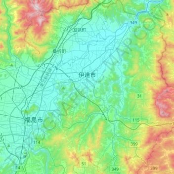
Name: 伊達市 topographic map, elevation, terrain.
Location: 伊達市, 福岛县, 日本 (37.68924 140.48285 37.91529 140.73666)
Average elevation: 232 m
Minimum elevation: 21 m
Maximum elevation: 903 m
Other topographic maps
Click on a map to view its topography, its elevation and its terrain.