
Kyankwanzi topographic map
Interactive map
Click on the map to display elevation.
About this map
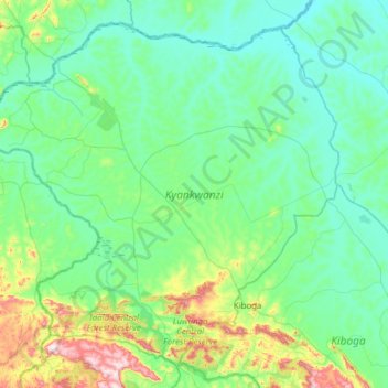
Name: Kyankwanzi topographic map, elevation, terrain.
Location: Kyankwanzi, Central Region, Uganda (0.81854 31.29162 1.36812 31.91333)
Average elevation: 1,126 m
Minimum elevation: 1,042 m
Maximum elevation: 1,533 m
The district area is full of lush green forests and prairies with minor elevation differences as it is the plateau behind the western fork of the East African Rift running across the Hoima District. The altitude is roughly 1,000–1,200 meters above sea level.
Other topographic maps
Click on a map to view its topography, its elevation and its terrain.
Panduku
Panduku, Pawor, Madi Okollo, Northern Region, Uganda
Average elevation: 672 m
Muyembe
Uganda > Sironko > Bugisa sub-region
Muyembe, Bugisa sub-region, Sironko, Eastern Region, Uganda
Average elevation: 1,392 m
Village 5 Zone 1
Village 5 Zone 1, Udupi, Arua, Northern Region, Uganda
Average elevation: 746 m
Merikit Centre
Merikit Centre, Tororo, Eastern Region, Uganda
Average elevation: 1,119 m
Rubaare (nyarweshama)
Rubaare (nyarweshama), Sheema, Western Region, Uganda
Average elevation: 1,525 m
Ruhoko - Nyinendugu
Ruhoko - Nyinendugu, Ibanda, Western Region, Uganda
Average elevation: 1,416 m
Stage
Uganda > Bulambuli > Bugisa sub-region
Stage, Bugisa sub-region, Bulambuli, Eastern Region, Uganda
Average elevation: 1,792 m
Lower
Uganda > Western Region > Mbarara City
Lower, Mbarara City, Western Region, Uganda
Average elevation: 1,407 m
Rushebeya B
Rushebeya B, Kambuga Sub-County, Kanungu, Western Region, Uganda
Average elevation: 1,191 m