
Kanungu topographic map
Interactive map
Click on the map to display elevation.
About this map
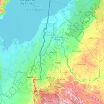
Name: Kanungu topographic map, elevation, terrain.
Location: Kanungu, Western Region, Uganda (-1.07630 29.58189 -0.33640 29.90189)
Average elevation: 1,237 m
Minimum elevation: 908 m
Maximum elevation: 2,495 m
The Kayonza Tea Factory and the Kigezi Development Tea Factories, one in Butogota Town Council and the other in Rugyeyo Subcounty, purchase and process the tea grown locally. The CHIFCOD Coffee Factory supports 1,000 farmers, training them to create high-value produce then processing and exporting it. The high altitude and fertile soils allow production of temperate fruits like grapes, apples, and pears.
Other topographic maps
Click on a map to view its topography, its elevation and its terrain.
Mantenga I
Uganda > Namisindwa > Bugisa sub-region
Mantenga I, Bugisa sub-region, Namisindwa, Eastern Region, Uganda
Average elevation: 1,595 m
Mwizi Central
Mwizi Central, Rwampara, Western Region, Uganda
Average elevation: 1,706 m
Panduku
Panduku, Pawor, Madi Okollo, Northern Region, Uganda
Average elevation: 672 m
Muyembe
Uganda > Sironko > Bugisa sub-region
Muyembe, Bugisa sub-region, Sironko, Eastern Region, Uganda
Average elevation: 1,392 m
Rubaare (nyarweshama)
Rubaare (nyarweshama), Sheema, Western Region, Uganda
Average elevation: 1,525 m
Village 5 Zone 1
Village 5 Zone 1, Udupi, Arua, Northern Region, Uganda
Average elevation: 746 m
Merikit Centre
Merikit Centre, Tororo, Eastern Region, Uganda
Average elevation: 1,119 m
Ruhoko - Nyinendugu
Ruhoko - Nyinendugu, Ibanda, Western Region, Uganda
Average elevation: 1,416 m
Stage
Uganda > Bulambuli > Bugisa sub-region
Stage, Bugisa sub-region, Bulambuli, Eastern Region, Uganda
Average elevation: 1,792 m
Lower
Uganda > Western Region > Mbarara City
Lower, Mbarara City, Western Region, Uganda
Average elevation: 1,407 m