
Mbarara topographic map
Interactive map
Click on the map to display elevation.
About this map
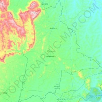
Name: Mbarara topographic map, elevation, terrain.
Location: Mbarara, Western Region, Uganda (-0.63005 30.43807 -0.20569 30.77858)
Average elevation: 1,482 m
Minimum elevation: 1,281 m
Maximum elevation: 2,168 m
Mbarara district consists of one municipality (Mbarara Municipality), and nineteen rural sub-counties, organized into two counties. Mbarara District covers a land area of 1,778.4 square kilometres (686.6 sq mi), with an average elevation of about 1,800 metres (5,900 ft) above sea level. The district receives an average annual rainfall of 1,200 millimetres (47 in). Temperatures range between 17 °C (63 °F) and 30 °C (86 °F).
Other topographic maps
Click on a map to view its topography, its elevation and its terrain.
Panduku
Panduku, Pawor, Madi Okollo, Northern Region, Uganda
Average elevation: 672 m
Muyembe
Uganda > Sironko > Bugisa sub-region
Muyembe, Bugisa sub-region, Sironko, Eastern Region, Uganda
Average elevation: 1,392 m
Village 5 Zone 1
Village 5 Zone 1, Udupi, Arua, Northern Region, Uganda
Average elevation: 746 m
Merikit Centre
Merikit Centre, Tororo, Eastern Region, Uganda
Average elevation: 1,119 m
Rubaare (nyarweshama)
Rubaare (nyarweshama), Sheema, Western Region, Uganda
Average elevation: 1,525 m
Ruhoko - Nyinendugu
Ruhoko - Nyinendugu, Ibanda, Western Region, Uganda
Average elevation: 1,416 m
Stage
Uganda > Bulambuli > Bugisa sub-region
Stage, Bugisa sub-region, Bulambuli, Eastern Region, Uganda
Average elevation: 1,792 m
Lower
Uganda > Western Region > Mbarara City
Lower, Mbarara City, Western Region, Uganda
Average elevation: 1,407 m
Rushebeya B
Rushebeya B, Kambuga Sub-County, Kanungu, Western Region, Uganda
Average elevation: 1,191 m