
Northern Region topographic map
Interactive map
Click on the map to display elevation.
About this map
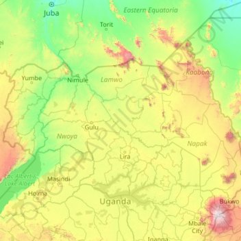
Name: Northern Region topographic map, elevation, terrain.
Location: Northern Region, Uganda (1.36524 30.74007 4.23408 35.00031)
Average elevation: 1,006 m
Minimum elevation: 454 m
Maximum elevation: 3,085 m
Other topographic maps
Click on a map to view its topography, its elevation and its terrain.
Mantenga I
Uganda > Namisindwa > Bugisa sub-region
Mantenga I, Bugisa sub-region, Namisindwa, Eastern Region, Uganda
Average elevation: 1,595 m
Mwizi Central
Mwizi Central, Rwampara, Western Region, Uganda
Average elevation: 1,706 m
Panduku
Panduku, Pawor, Madi Okollo, Northern Region, Uganda
Average elevation: 672 m
Muyembe
Uganda > Sironko > Bugisa sub-region
Muyembe, Bugisa sub-region, Sironko, Eastern Region, Uganda
Average elevation: 1,392 m
Rubaare (nyarweshama)
Rubaare (nyarweshama), Sheema, Western Region, Uganda
Average elevation: 1,525 m
Village 5 Zone 1
Village 5 Zone 1, Udupi, Arua, Northern Region, Uganda
Average elevation: 746 m
Merikit Centre
Merikit Centre, Tororo, Eastern Region, Uganda
Average elevation: 1,119 m
Ruhoko - Nyinendugu
Ruhoko - Nyinendugu, Ibanda, Western Region, Uganda
Average elevation: 1,416 m
Stage
Uganda > Bulambuli > Bugisa sub-region
Stage, Bugisa sub-region, Bulambuli, Eastern Region, Uganda
Average elevation: 1,792 m
Lower
Uganda > Western Region > Mbarara City
Lower, Mbarara City, Western Region, Uganda
Average elevation: 1,407 m